Day 82 – Ingonish to North Sydney – 94 kilometers

Thursday August 23rd

Big Smokey eh!

Last night I had briefly spoke with another cyclist from Cape Breton. His name is Jimmy Cambell who is a teacher in Sydney. He has only been riding 5 -7 years but he has done the Cabot Trail many times. I would put him in his 60’s but he is in solid shape. He is currently promoting riding in Nova Scotia so please check it out:

www.velocapebreton.ca

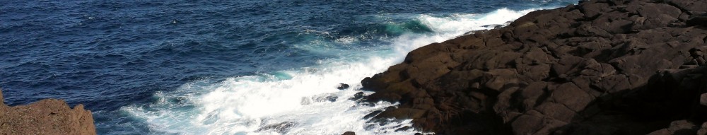
He left earlier and we played tag a bit since we had different stops but we would catch up to each other later in the day. After Ingonish you sweep into a long bay and then head up Cape Smokey which is not too bad a climb in this direction but heading counter clockwise on the Cabot Trail would present a challenge. The view is not bad at the main pull out but I found a little outcropping just down the road that you can not get to if you have a car because there is no where to pull over. I had pulled over because the cars are going to slow on the steep downhill.
image
image
image
image

The ride from there was a windy long downhill which I flew down but going the other way would suck as I mentioned because there is no shoulder plus you would be going very slow up the mountain. After that there wasn’t much to see since there were houses and forest between the road and the sea shore. Once and a while you would get a glimpse but pretty boring riding if you ask me. Finally you come out of there to very large inlet with a causeway and a ferry to the other side. The ferry only goes about 50 meters and it has a tether due to the strong current. After about 6 kilometers you join back up with the Trans Canada where I met some cyclists near the top of the hill. They had left 2 days after me from Victoria but they rode almost every day which I think is very tough to do. They had a lot a of gear and even a fiddle!!!! They were going to the Rollies Wharf in North Sydney for a fiddle jam. Not too long after Jimmy Cambell pulled up and we chatted for a good half hour before I pressed on.
image
image

There was a another big downhill all the way to the bridge to Seal Island. The bridge has no shoulder and gusty winds. Not for the faint of heart or inexperienced cyclists. You are not allowed to cross on foot because it is so narrow and dangerous. Up the other side I pulled into a service station for some chocolate and fluids since I had run out about an hour ago. I saw Jimmy ride by so I hopped on the bike and tracked him down. We rode for a little ways but I had a little more energy up the hill and the other side was a huge downhill with a tailwind. I hadn’t been in the big rim on a slight downhill for a while and I didn’t wait up since there were big rollers too. I really kept my speed over most of them making the climbs easy. It was nice to finish the day like that as I saw the campground not too far after.
image

I booked in and then called the ferry service to Newfoundland. Bad News 🙁 The next reservation is for Saturday, can’t fit little me on the ferry I guess! I showered, did laundry then went for dinner at a local pub. There was hardly anyone in there so I chatted with the bartender (he actually came to my table and sat with me) for while. Nice guy who was into kayaking. Jobs are pretty scarce around here but he ran the pub so he was okay. After having the second best burger on the trip I went back to camp discover that my tent had fallen in on itself. This was a first. When I set it back up I noticed something had gnawed through the back and had gotten to all of my bagels, what is it with bagels??? All things considered I have been pretty lucky animals but those pesky Scottish Chipmunks!!!!

I took a cab to Rolliee’s Wharf to catch the fiddle off. There was a good 7 or 8 fiddlers, a piano player and at times small wind instruments. It was pretty good but the songs are long and I sensed that not all the participants know them or the lead is simply extending the song on and on. Other than having to wait an extra day things are good. Please note there are only 8 more days to donate. People have been very generous so far and we are closing in on $12,000 so I am very happy.
image
image

Day 81 – Cheticamp to Ingonish (Cabot Trail Provincial Park) – 117 kilometers

Wednesday August 22nd

Check out the hills on this baby!

This morning I had a show down with the chipmunks of Cheticamp. It started because while getting ready to go I had unloaded everything, including food, from the tent. I had gone to brush my teeth and when I came back I saw Tricia had come over and was trying to shoo something away. Low and behold there he was with butterscotch chip cookie bag in his mouth trying to drag it off the table. He didn’t want to give it up and when the bulk of it fell over the side of the picnic table he couldn’t hold on and it crashed to the ground. I jumped in with the quickness of a cat and grabbed my cookies! While I was gone they had also chewed through my bagel bag and did a little nibbling on not just the top one but a couple of them. I through those to the ground and they started coming back for the scraps. One tried to take a full bagel a d could barely move it so I went to grab it and he held on to the last minute before scurrying away. I broke that piece into small pieces and within a minute another was back but head chipmunk chased him away, it is fierce in the wilderness.

The day started right into a climb of the biggest mountain here which is named French Mountain. It is only around 500 meters high but the ride is a pretty good one and I felt like I was back in BC. The view was of course incredible and it was a nice and cool overcast day with the wind blowing from the North. This made for great riding even though it was hard. Even the cars and trucks were having a little trouble. I wonder what they think when they see me. At the top of the climb is Skyline trail which Amanda and Pictou had suggested that if I do any trail to do this one. I have to thank her since this is a spectacular trail once you get out to the edge of the ridge. You see the park on your left when you are heading up the road which you can see in the pictures I post. For those that do it, skip the loop and just go straight to the Western lookout. I met two Aussie girls who did the trail with me which was nice since 5 kilometers of it had little or no view. I can’t do the views justice with my pathetic writing skills so have a look below:

image
image

image

The Skyline trail runs along the top of this ridge.


image

Skyline loop


image

Looking back at the highway where I took the earlier picture.


image
image

On the way back I saw my first moose! She was small but very close to the trail so I waited until she relaxed and came close to the trail to capture some video. It was pretty cool to see a big animal so close and with little danger since I don’t think the females are aggressive which is unlike Albatrosses with their dangerous flight patterns but I digress.
image

The top of the hill was just a little further and then you are on a very large plateau which has at least one lake, brown grassy areas and some smaller old twisted trees. I suspect the wind can get horrendous up here but it was all blue skies now since the wind had pushed the clouds away. It was only hot when the wind stopped so I kind of liked the wind. The road wound back toward the sea for another spectacular view of a little beach where a fishing village used to exist. You can hike down the 8 kilometers but I had already hiked 9 kilometers today and need to ride 100 or so more kilometers so I continued along the road.
image

There is a massive windy downhill into Pleasant Bay that without a weighted down bike and the blowing wind would be an incredible descent. It was still pretty awesome and no traffic could keep up to me, not even close. I stopped at a little restaurant around the bottom before the the bay and had a lobster wrap. It was good but I guess I am not a seafood person because I never really enjoy it so much I want more. Out of Pleasant Bay comes some unpleasantness as you hit North Mountain which has a 13% grade for about 4 kilometers. Now this was a hard ride and ranked up there with some of the climbs in BC with some really steep parts. Part way a couple who were riding with a tour company were stopped waiting for the van. I didn’t stop but asked if they were okay to which the man retorted “it is too hard”. Further up a lady was walking up and she simply yelled “impressive” which made me feel good. The tour van passed me slow enough to yell out some encouragement as well. Knowing it was only 4 kilometers I got pretty stubborn and just cranked it as hard as I could without stopping. It had a kind of gradual crest and seeing the tour van parked beside the road I started ratcheting up the gears until I passed them doing about 30 km/hr at the crest and then I put the hammer down and blew by some cyclists who had gotten the free ride doing about 50km/hr. The road then dipped really steeply into about 10 small switchbacks with speed warnings of 30km/hr. The wind was howling in every direction but I was smoking down the hill and didn’t stop for pictures. I was cutting the corners massively and accelerating out of them to about 65km/hr when I dared to look down at the odometer. I blew by a cyclist who had stopped at a lookup and just held the corner enough to make it around but by then I decided I had played the game for enough now and stopped at the next look out. The lady whom I had just passed couldn’t believe how fast I came down. She was from Texas and the tour group had said this was a moderate ride. I would say it was far from moderate and would not recommend North Mtn. except for experienced cyclists.
image
image
image

There was a nice long ride out before it went into rolling hills. The road continued to remain shoulder less and there seemed to be a bit more traffic. It was still a ways away from the coast but I just kept riding for as long as I could with taking as few stops as possible. Eventually you come out of the forest to the Southern coastline which is much more scenic than the North in my opinion. The ocean thrashes the large rocky coast line into rounded stone of pinkish colour. I love the crashing sound, it reminds me of Hawaii near Sunny Beach. I stopped at one of the lookouts that had a great view of Black Brook Cove (I think)) with its large sand beach and break waters about 500 meters from the shore. I rode a little father to the next stop and climbed out onto the rocks to get a little closer to the action.
image
image

I eventually made it to Ingonish campground and setup for the night. I had my final night of noodles since I planned to ditch my pot and stove in the morning. A very hard day of riding but the great views on the Cabot trail made it worth it.